TPVT RELATIONSHIP IN REGIONAL PLANNING OF BA RIA - VUNG TAU PROVINCE VISION TO 2025
(Approved in Decision No. 3064/QD-UBND VUNG TAU dated September 11, 2008)
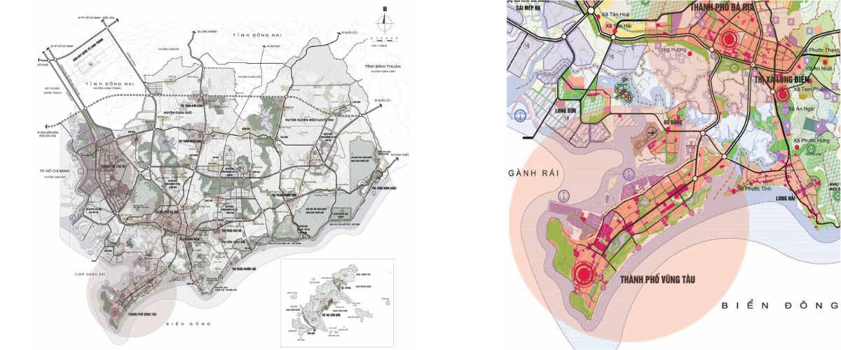
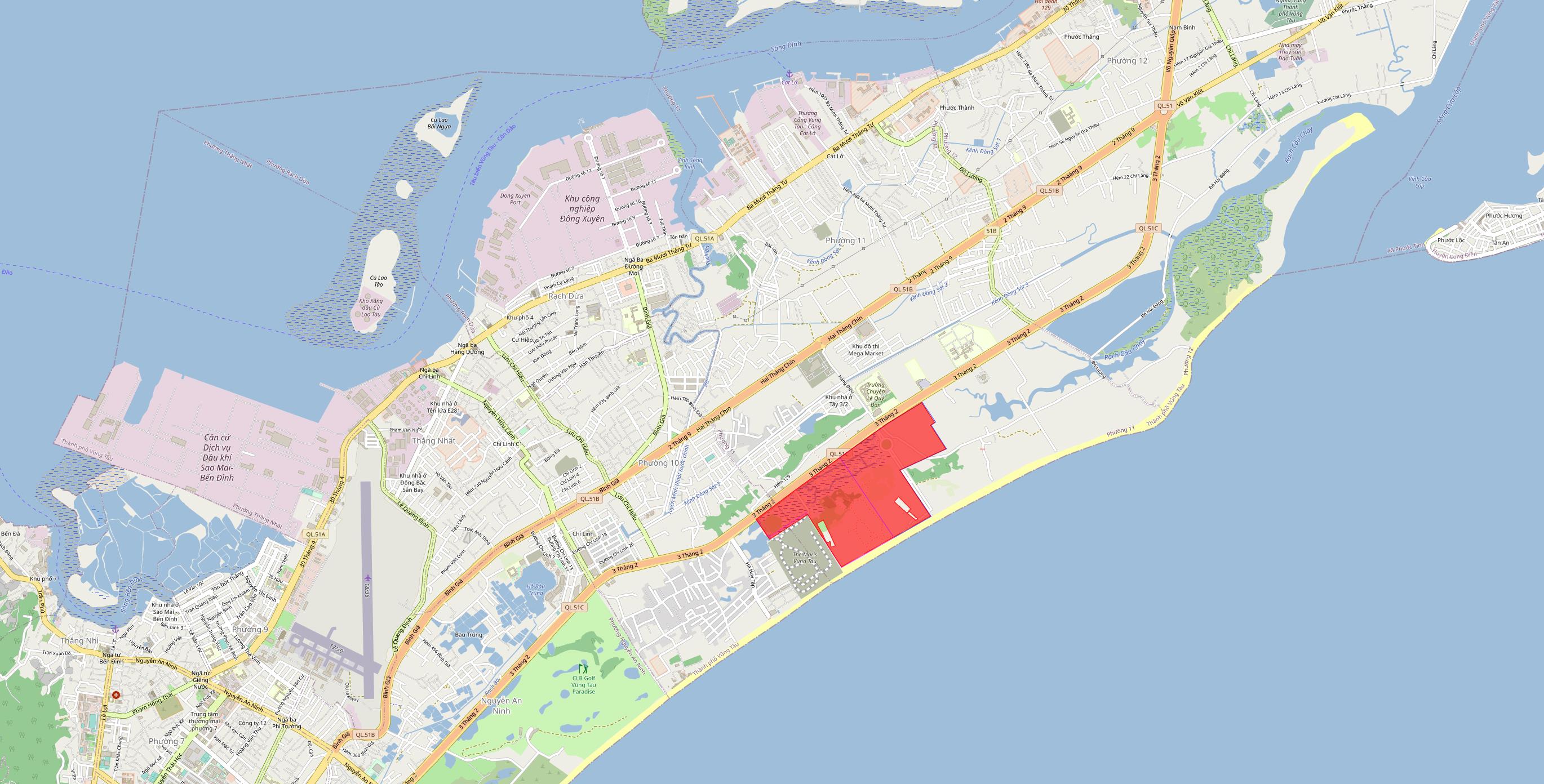
Vung Tau city is located in the south of BR-VT province, has 3 sides bordering the East Sea, far from Ho Chi Minh City and Ho Chi Minh City. Bien Hoa is about 95km, the city has an area of 15,043 hectares;
Vung Tau city is a class I urban area, a sea tourism city, and an international beach resort center. Delivery focal point, seaport service center and oil and gas service exploitation of the country.
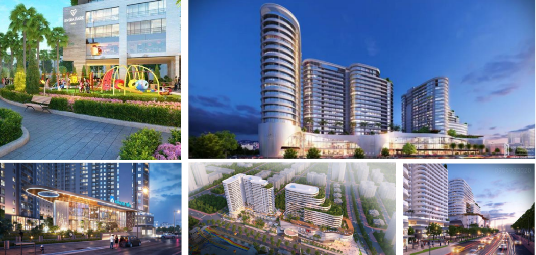
Some major projects are opening up for the strong future development of Vung Tau City:
- Long Thanh Airport
- Bien Hoa - Vung Tau expressway
- Provincial Road 994
- International passenger ship port project in Vung Tau city
PROJECT OF ADJUSTING GENERAL PLANNING OF VUNG TAU CITY TO 2035 APPROVED BY PRIME MINISTER OF PHU IN DECISION NO. 586/QD -TTG DATED MAY 17, 2019
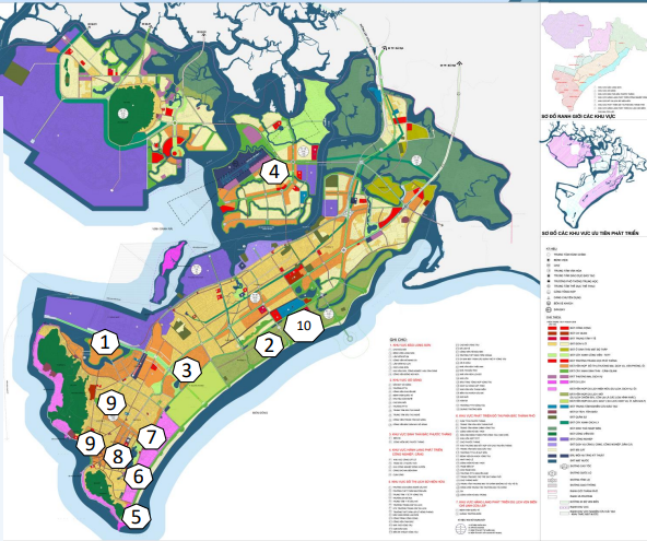
After the General Plan was approved, the City organized the preparation and adjustment of 10 Master Plans 1/2000. Up to now, the Provincial People's Committee has approved 07 subdivision planning projects including North Vung Tau, Chi Linh - Cua Lap, Bai Sau, Bau Trung, Ben Dinh Island, Long Son Island, North Phuoc Thang Area. 3 projects are being completed and submitted for appraisal: Nam Vung Tau, Go Gang and Big Mountain - Nho Mountain (DXD).
Throughout Vung Tau city, there are 10 areas that are being implemented to call for investment:
1. Cu Lao Ben Dinh urban area;
2 . 3/2 Street Urban Area;
3 . Bau Trung Cultural Park - New Urban Area;
4. Go Gang Island Area;
5. Nghinh Phong Cape Area;
6. Area 4.3 hectares, corner of Thuy Van - Hoang Hoa Tham street;
7. Tourist Market (old);
8 . Public land area on Le Hong Phong street (crayfish area);
9. Areas of clusters 3, 4, 5;
10. General hospital in Ward 11.
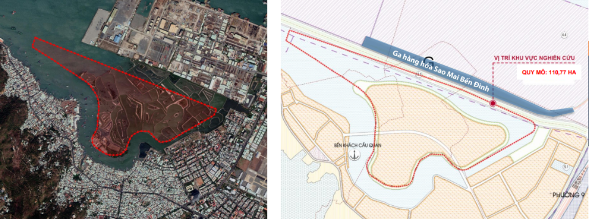
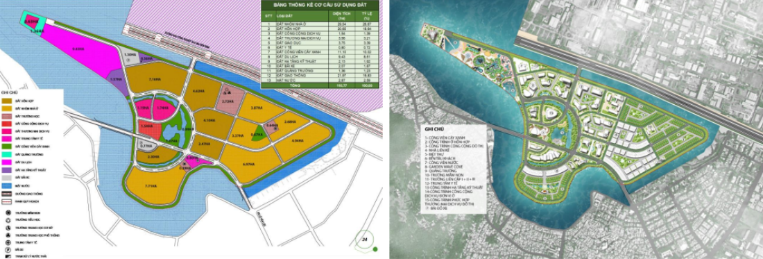
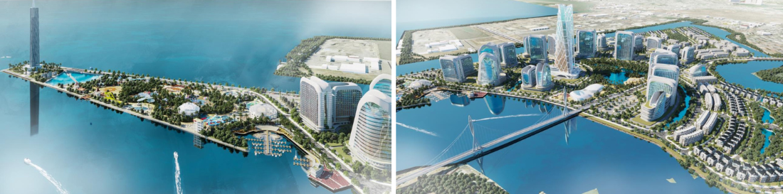
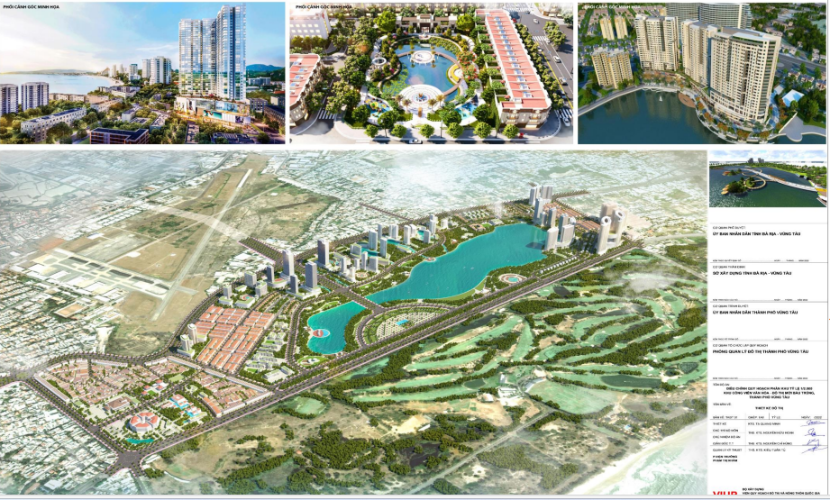
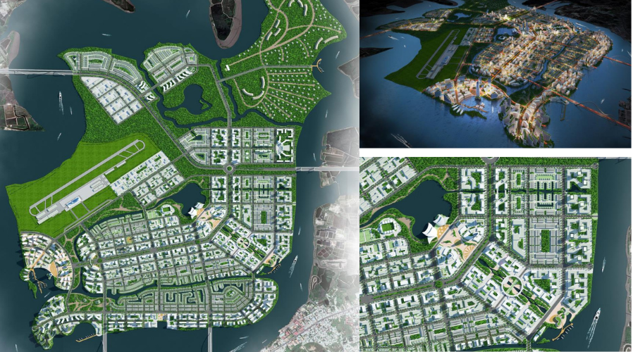
1. CU LA BEN DINH URBAN AREA
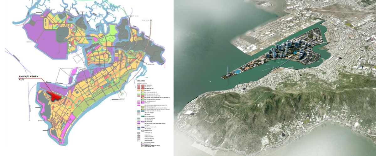
| LOCATION OF BEN DINH ISLE IN THE OVERALL OF VUNG TAU CITY | DECISION NO. 1208/QD-UBND DATED APRIL 14, 2022 OF THE PROVINCIAL PEOPLE'S COMMITTEE APPROVED THE PLAN 1/2000 OF CU LA BEN DINH ISLAND URBAN AREA |
The Ben Dinh island area is planned as a service urban area, forming a modern new urban area with mixed functions including housing - commercial services - offices and ensuring a social infrastructure system, Technical infrastructure in residential areas.
Ben Dinh is a semi-flooded area in wards 5, 9 and Thang Nhi ward (Vung Tau city), the entire island is adjacent to the Ben Dinh Canal route. This canal route is adjacent to the following areas:
|
The total area of Ben Dinh island urban area is about 110.77 hectares. The Ben Dinh island area is currently uninhabited. |
Total investment in construction of items in the project is expected to be approximately 30,000 billion VND
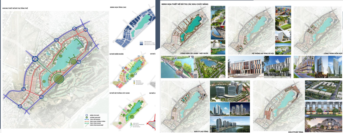
| LAND USE PLAN | ORGANIZATION CHART OF LANDSCAPE ARCHITECTURE SPACE |
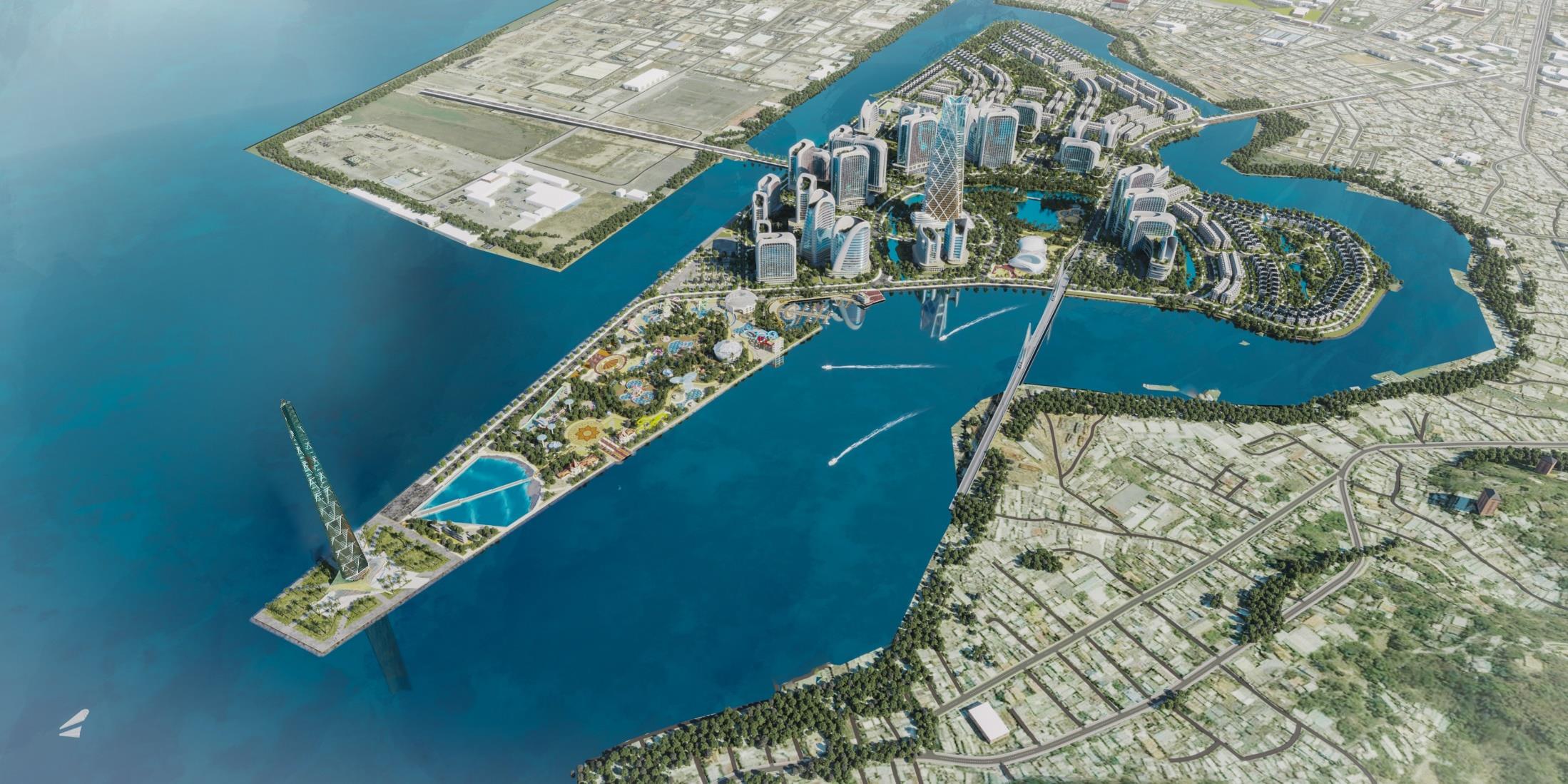
PERSPECTIVE OF THE PROJECT (view from the southwest)
PERSPECTIVE AND SPACE ILLUSTRATION OF THE PASSENGER SHIP AREA (MARINA)
| PERSPECTIVE OF THE PROJECT (view from the northeast) |
OVERALL NIGHT PERSPECTIVE OF THE PROJECT |
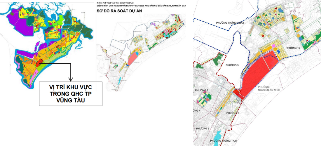
2. FEBRUARY 3 STREET URBAN AREA
LOCATION AND REGIONAL RELATIONSHIPS
PROJECT LOCATION
The research area belongs to the administrative boundaries of Ward 10 and Ward 11, Vung Tau city.
Belonging to the scope of the 1/2000 scale zoning project of Chi Linh - Cua Lap tourist area, Vung Tau city.
• Northwest borders: Road 3/2;
• The Southwest borders: Vung Tau Regency tourist area project;
• The Northeast borders: Current land area of Ward 11;
• The Southeast borders: Road D10 and the East Sea.
The area covers the entire land area transferred from the Vietnam Bank for Industry and Trade in Ward 10 and Ward 11 with a total area of 93.6 Ha.
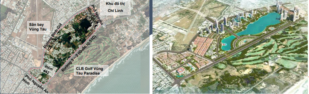
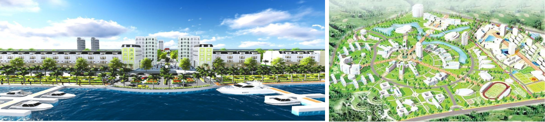
FORMING A COMPLEX URBAN AREA, A MODERN TOURISM URBAN, WITH SYNCHRONOUS TECHNICAL AND SOCIAL INFRASTRUCTURE
The main function is housing, tourism services combining various types of services serving housing areas and tourist areas. Currently, the City People's Committee is organizing the establishment of a 1/500 scale master plan in this area.
3. BAU TRUNG NEW URBAN - CULTURAL PARK
LOCATION AND SCOPE OF PLANNING BOUNDARIES
Area boundaries:
+ The Northeast borders Nguyen Huu Canh street
+ The southwest borders Nguyen An Ninh street
+ The Southeast borders Road 3/2 (National Highway 51C)
+ Northwest borders Binh Gia street (Road 2/9) Area scale: 172.99 hectares
| CURRENT STATUS OF THE AREA | DECISION NO. 3833/QD-UBND DATED DECEMBER 16, 2022 OF THE PROVINCIAL PEOPLE'S COMMITTEE APPROVING THE ADJUSTMENT PLAN OF PLAN 1/2000 OF CULTURAL PARK - BAU TRUNG NEW URBAN, NGUYEN AN NINH WARD, VUNG TAU CITY |
1. Area scale: about 172.99 hectares (including part of the lakeside area of the Chi Linh Central Area project implemented as a separate project).
2. Forecast population size: About 40,000 people; in which: permanent population size is about 33,000 people and converted population size is about 7,000 people.
3. Characteristics: It is a cultural, sports, entertainment service park associated with green trees, landscape lakes and regulating lakes of Vung Tau city; is a renovated and embellished housing area combined with public works from Nguyen An Ninh street to alley 442 Binh Gia and social housing area, on-site resettlement housing area; is a new commercial and urban housing area with modern investment, in harmony with the general landscape of Vung Tau city.
SCALE AND NATURE OF PLANNING
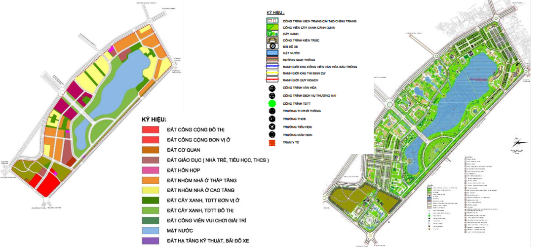
The area is divided into 3 sub-zones, including:
- Sub-area 1 (23.0 ha): Urban area to be renovated and embellished (urban renovation).
- Sub-zone 2 (110.27 hectares): Bau Trung cultural park - new urban area (urban reconstruction, new urban area).
- Subzone 3 (39.72ha): Chi Linh urban area;
LAND USE PLANNING STRUCTURE
URBAN DESIGN
LOCATION MAP CONTACT
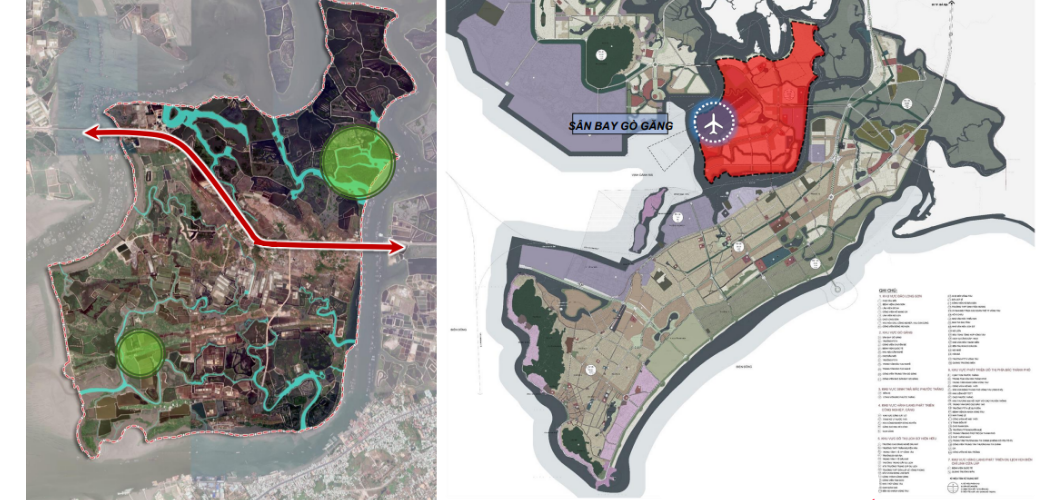
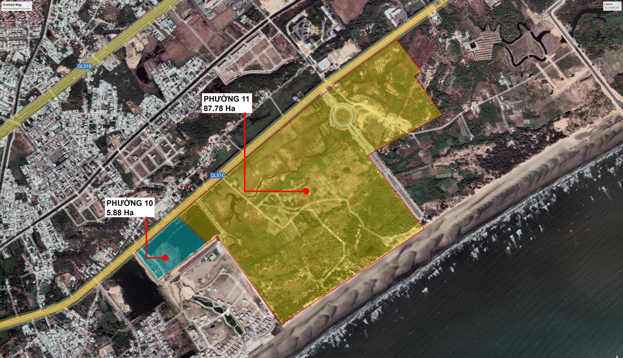
Scale of project area:
1,389 hectares. Estimated population size: 60,000 people. Boundary range:
+ The North borders Rang River, the section flowing through Go Gang Island is Cha Va River and Mui Gui River;
+ The West borders Cha Va River; + The East and South border Dinh River;
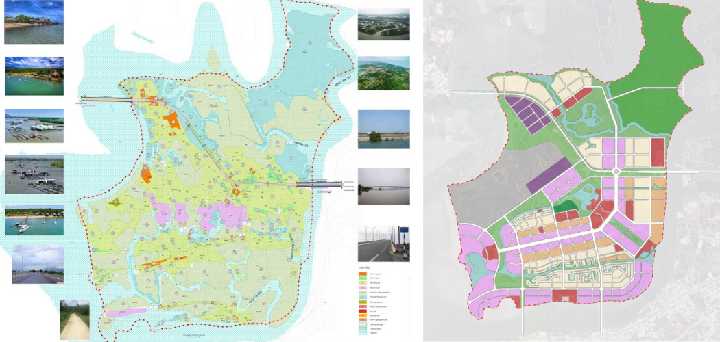
| CURRENT LAND USE STATUS |
LAND USE PLANNING OPTIONS |
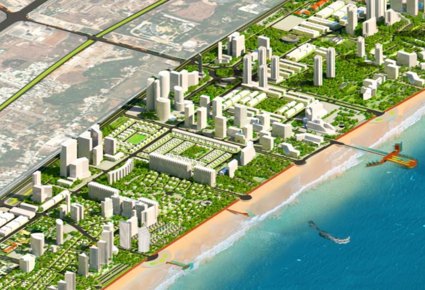
It is a modern new urban area associated with Go Gang airport and associated with mangrove ecological space; Forming a high-tech fisheries logistics and seafood processing service center. It is a sustainable urban area with unique characteristics of Vung Tau city, formed on the basis of exploiting the topographical features, water surface and natural landscape of Go Gang island; Optimize the potential, natural landscape of water surface, rivers and canals, seascape, as well as land fund for urban development... to become a unique international-class coastal urban area, with investment efficiency and high development feasibility.
PLANNING OBJECTIVES
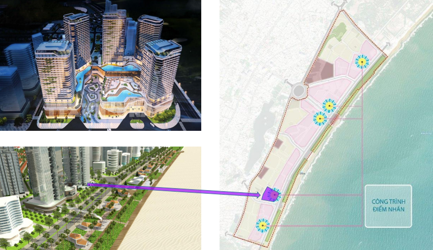
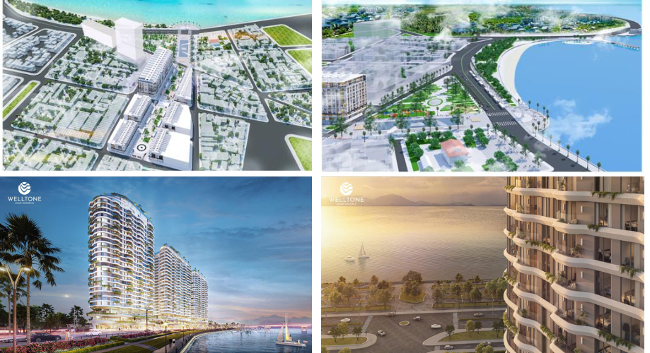
5. NGHINH PHONG CAPE
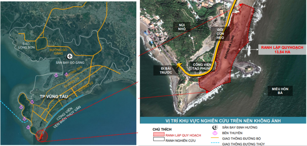
The planning area is geographically located south of Vung Tau city, in Ward 2, Vung Tau city.
- The Northwest and Northeast borders: Ha Long road;
- The remaining sides border: East Sea.
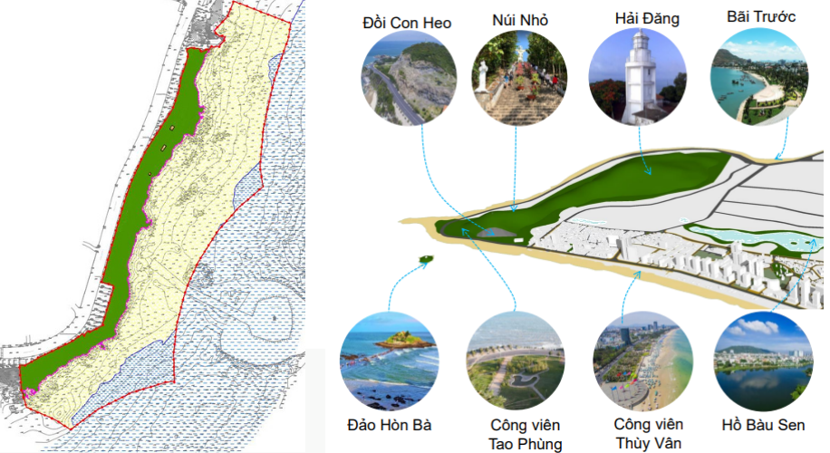
| CURRENT LAND USE STATUS DIAGRAM | Location near Seaports and Marinas. It is the starting point of Thuy Van Coastal Park. Adjacent to Hon Ba Temple, Nho Mountain, Pig Hill,... |
TARGET :
- CLASS, LUXURY RESORT ON THE BEACH
- RESPECTING THE TERRAIN AND NATURAL BEACH
- HIGHLIGHT THE CULTURAL CHARACTERISTICS OF TPVT
- MAKE A BRAND CHECKIN POINT, CONNECT THE SURROUNDING AREA
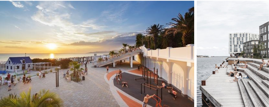
PLANNING ORIENTATION
LUXURY RESORT SPACE WITH SEA VIEW
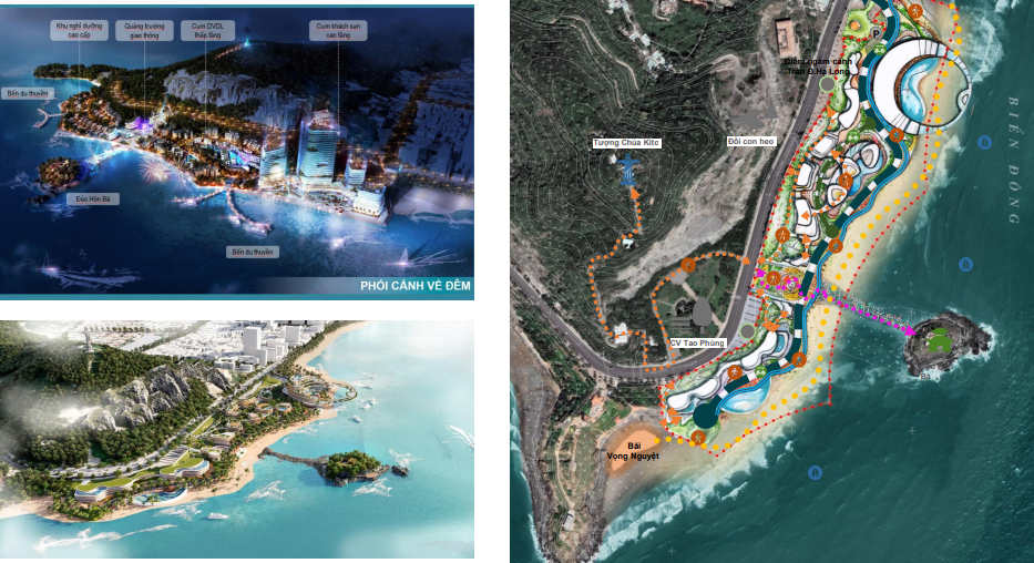
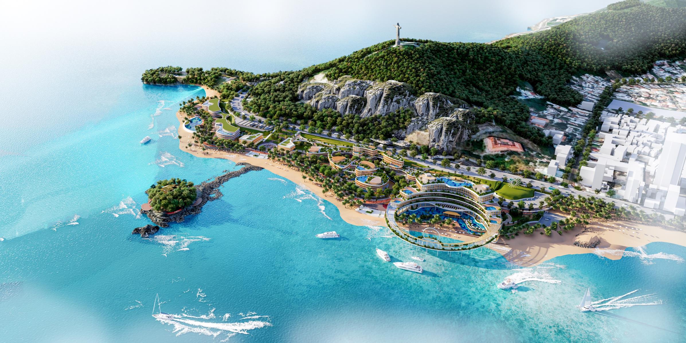
PROJECT PERSPECTIVE
6. 4.3 HA AREA CORNER OF THUY VAN - HOANG HOA THAM STREET
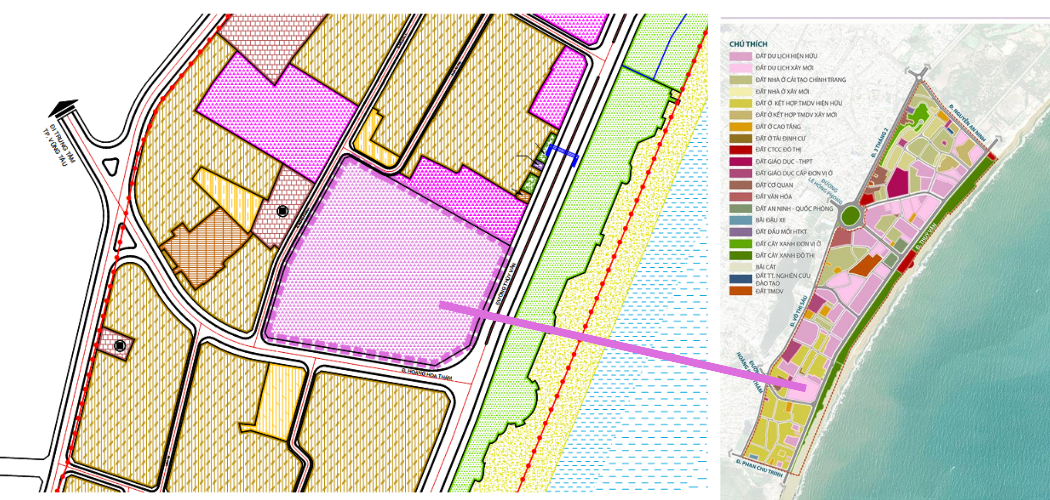
LOCATION MAP CONTACT FROM THE 1/2000 BEACH PLAN
Project area scale: 4.35 hectares.
Boundary range: Thang Tam Ward, City. Vung Tau
+ The Southeast borders Thuy Van street; + The southwest borders Hoang Hoa Tham street;
+ The Northwest borders Pho Duc Chinh street
ZONING:
- Characteristics: tourist land
- Land area: 4.35 hectares.
- Floor height: from 01 - 45 floors;
- Maximum construction density 40%;
- Basement: from 02 - 05 floors.
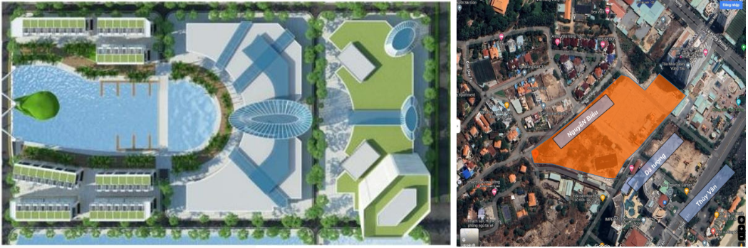
7. TOURISM MARKET (old)
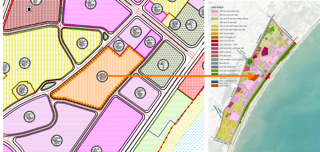
| Project area scale: 2.87 hectares.
Boundary range: Thang Tam Ward, Vung Tau City + The Southeast borders Gia Tuong street; + The southwest borders the planned road; + The Northwest borders Nguyen Bieu street |
LOCATION MAP CONTACT
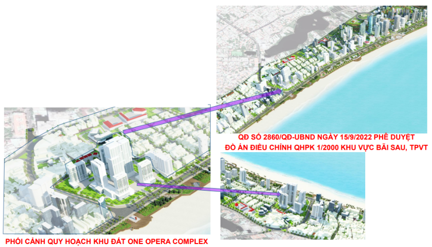
Decision No. 2860/QD-UBND DATED SEPTEMBER 15, 2022 APPROVING THE PLAN OF ADJUSTING PLAN 1/2000 FOR THE BEACH AREA, TPVT
|
| ORIENTATION FOR COMMERCIAL AREA AND HIGH-LEVEL TOURISM SERVICES |
CURRENT STATUS OF TOURISM MARKET LAND |
ZONING:
- Area: 28,756.0m2; - Maximum construction density: 40%;
- Floor height: from 40-50 floors; - SDD coefficient: 6.5
TARGET:
- Build a high-class commercial center, diverse services, modern and unique architecture; brings domestic and foreign tourists to enjoy a high-class commercial, shopping and resort area.
7. 4.3 HA AREA CORNER OF THUY VAN - HOANG HOA THAM STREET
| PLANNING ORIENTATION | ZONE PLAN 1/2000 BACK BEACH |
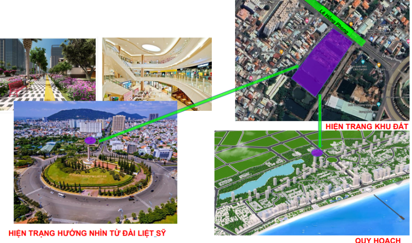
8. PUBLIC LAND AT LE HONG PHONG STREET
(Crayfish area)
LOCATION MAP CONTACT
Project area scale: 1.4 hectares. Boundary range: Ward 2, Vung Tau city
+ The Northeast borders Le Hong Phong street; + The southwest borders Bau Sen lake;
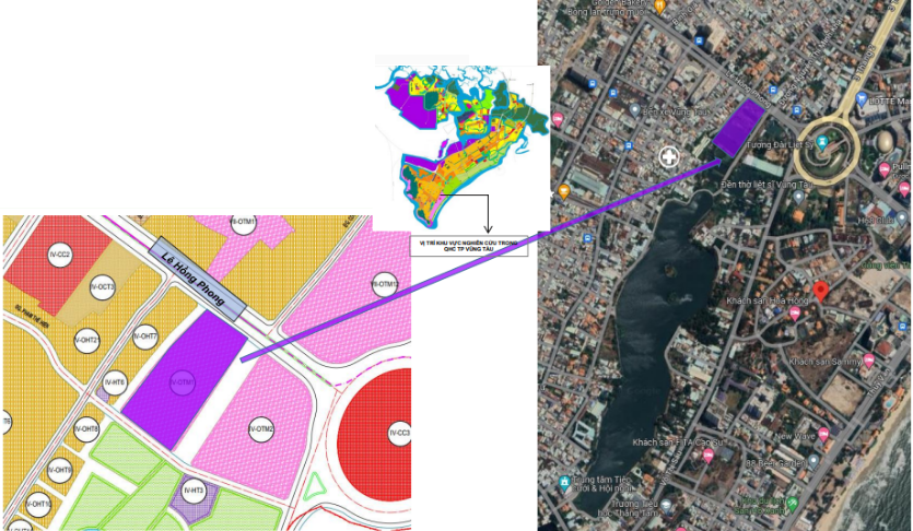
- Expected planning nature: trade - service
- Area: 1.4 hectares;
9. CLUSTER LAND AREA 4
Project area scale: 5.6 hectares.
Boundary range:
+ The southwest borders Le Hong Phong street;
+ The Southeast borders Nguyen Thai Hoc street
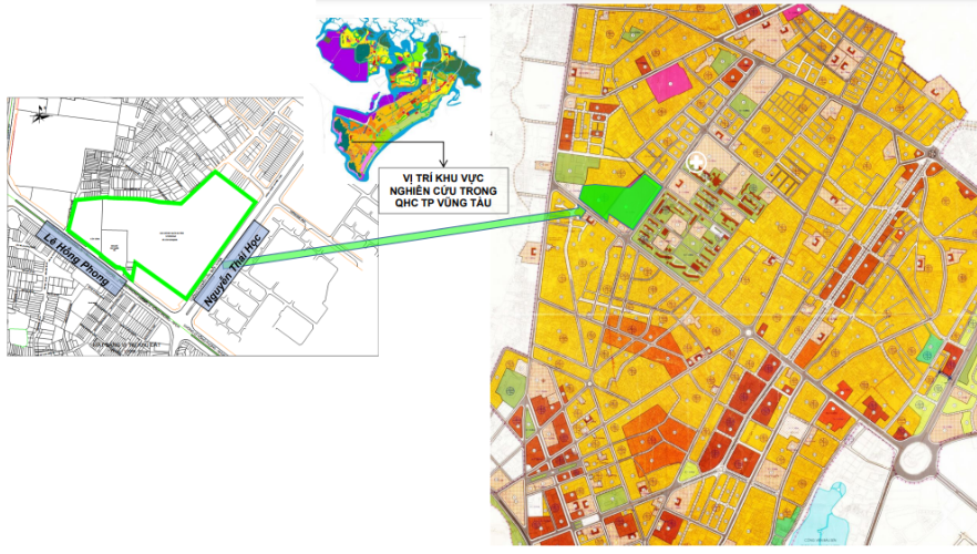
LOCATION MAP CONTACT US ACCORDING TO SOUTH AIRPORT RIGHTS
|
EXPECTED PLANNING OPTIONS Commercial - service orientation. - Area: 5.6 hectares; - Maximum construction density: 40%; - Maximum floor height: 30 floors; |
|
CURRENT STATUS: - Land of the Provincial Military Command |
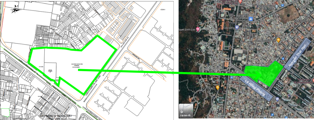
| CLUSTER LAND PLANNING BOUNDARIES 4 | CURRENT STATUS OF CLUSTER 4 LAND AREA |
Service land (commercial - service).
VISION ORIENTATION
9. CLUSTER LAND AREA 5
Project area scale: 2.81 hectares.
Boundary range:
Ward 1, Vung Tau city;
+ The Northeast borders Tran Hung Dao street;
+ The South borders Nguyen Du street;
+ The southwest borders Quang Trung street;
+ The Northwest borders Thong Nhat Street
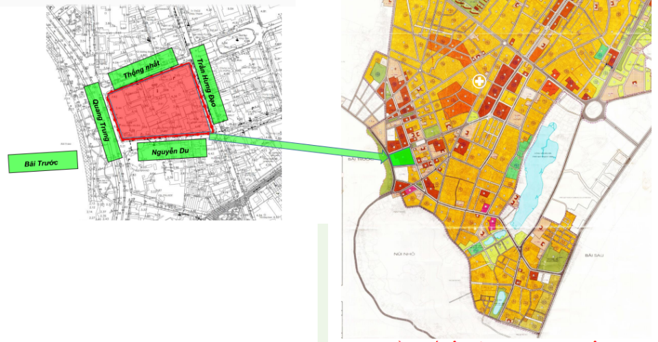
LOCATION MAP CONTACT US ACCORDING TO SOUTH AIRPORT RIGHTS
|
EXPECTED PLANNING OPTIONS: - Area: 2.81 hectares; - Maximum density: 55%; - Maximum height: 45 floors; - Basement: from 01-05 floors |
CURRENT STATUS: - Children's cultural houses; - Provincial police headquarters; - Provincial police gas station; - City police headquarters |
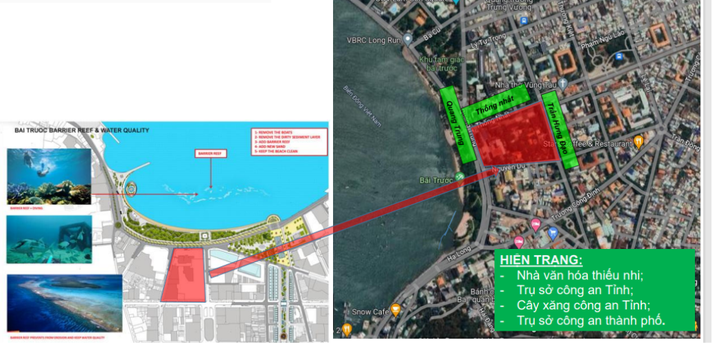
| CLUSTER LAND PLANNING 5 | CURRENT STATUS OF CLUSTER 5 |
Service land (commercial - service).
VISION FOR CLUSTER LAND ORIENTATION 5
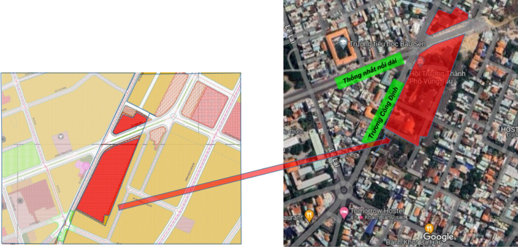
Project area scale: 4.2 hectares.
Boundary range:
+ The Northeast borders the extended Thong Nhat street;
+ The Northwest borders Truong Cong Dinh street;
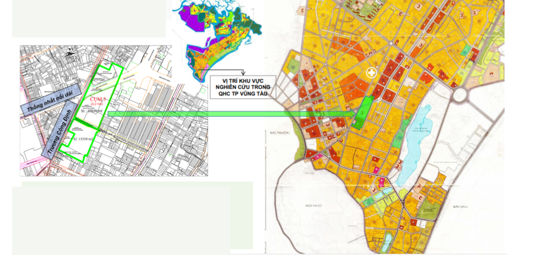
LOCATION MAP CONTACT US ACCORDING TO SOUTH AIRPORT RIGHTS
|
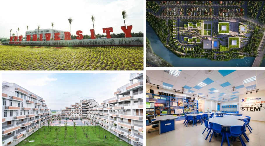
Expected planning plan: - Nature: Land for school construction; - Function: Building a complex of high-quality education and training projects with all levels of education from Kindergarten to post-university. - Land use planning criteria: + Maximum construction density: 40%; + Maximum floor height: 04 floors |
CURRENT STATUS: - Political school land, dormitory area; - Party Committee Headquarters of the Party's Civic Sector; - Party Committee headquarters of the enterprise sector; - Ba Ria Provincial Party Committee Hall - Vung Tau. - Provincial Party Committee office land |
| PLANNING LAND BOUNDARIES | CURRENT STATUS OF CLUSTER 3 LAND AREA |
Implement an inter-level education complex project.
VISION ORIENTATION
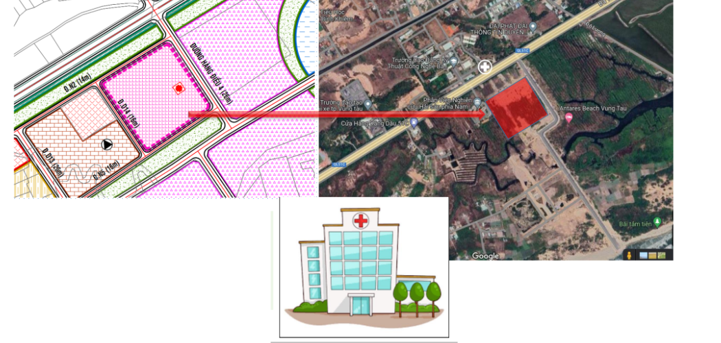
10. GENERAL HOSPITAL PROJECT IN WARD 11
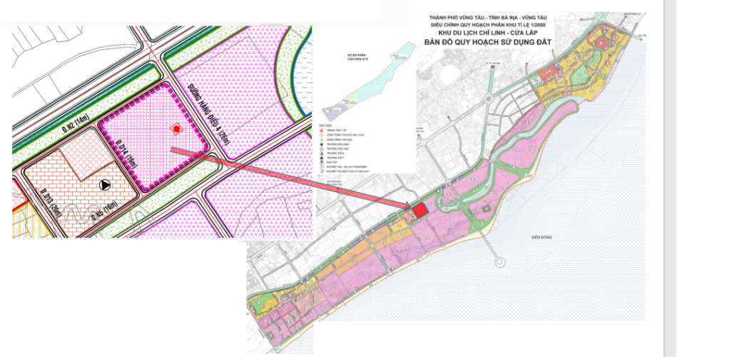
| Project area scale: 4.04 hectares.
Boundary range: + The Northeast borders Hang Dieu 4 street; + The southwest borders planning road D14; + The Northwest borders 3/2 Street; + The Southeast borders the planning road D.N5 |
LOCATION MAP CONTACT
Decision No. 1613/QD-UBND DATED June 1, 2022 APPROVAL ADJUSTMENT PLAN OF 1/2000 Master Plan CHI LINH TOURIST AREA - CUAP AP, TPV |
PLANNING: Medical land
- Land area: 4.04 hectares.
- Floor height: from 01 - 10 floors;
- Maximum construction density 40%
CURRENT STATUS OF THE PROJECT LAND